
Since Sugar Mountain is located high in the Blue Ridge Mountains, it’s a great basecamp for the best hiking to panoramic scenery, lush woodlands and waterfalls. Our mile-high village is surrounded by Pisgah National Forest, Grandfather Mountain State Park and the Blue Ridge Parkway – home to hundreds of miles of trails. Come discover options for all fitness levels, ranging from casual forest strolls to strenuous full-day hikes to remote mountaintops. All of these are within 20 miles of Sugar Mountain and Banner Elk.
Stay in a vacation rental on our mountain to be near the trails. Get outside and explore. Click on the names for a full hiking guide.
20 Hikes & Waterfalls in the High Blue Ridge of NC
Williams Park: On Sugar Mountain, our “central park” is a wooded 14-acre boulderfield forest with three short hiking trails that follow a cascading stream. Take a scenic stroll and a picnic in the pavilion. Read more.
Moses Cone Park: This public park on the Blue Ridge Parkway is a hiker’s dream since it has 25 miles of historic carriage roads that are now wide trails with a very gradual incline. Hike through rolling pastureland, by lakes and even to a fire tower. The park and historic home is a 14-mile drive from Sugar Mountain, and part of our 55-mile Parkway Loop Drive. Here are three top picks there:
- Flat Top Road Trail: This 5-mile roundtrip hike takes you to the summit with the historic lookout tower to climb for 360-degree views that include Appalachian State University. Read more.
- Bass Lake: An easy 8/10 of a mile loop takes you around the lake and connects with other trails to create a more challenging 4 to 6 mile loop. Read more.
- Rich Mountain: A 5-mile roundtrip hike than can be extended to more than 11 miles. Hike by a lake and through a dense forest with places for views along the way. Read more.
Price Lake: Near Moses Cone Park is Julian Price Park with a lake along the Blue Ridge Parkway. A 2.5-mile loop trail is mostly flat with plenty of lake vistas. Read more.
Cragway Trail Loop: This beautiful loop hike utilizes several trails inside Grandfather Mountain State Park. The trailhead is located on the Blue Ridge Parkway (near Price Lake), about 15 miles from Sugar Mountain. This 4-mile hike climbs steadily about 1,000 in elevation. Read more.
Green Knob / Sims Pond: Inside Julian Price Park is a 2.4-mile loop trail by a pond and cascades and through a highland pasture. Read more.
Boone Fork Trail: Another loop trail in Julian Price Park is 5 miles, taking you by many small waterfalls and through rhododendron tunnels. Read more.
Grandfather Mountain: Find a variety of trails near the famous Swinging Bridge, moderate to strenuous. The ridgetop Grandfather Trail is probably the most challenging but rewarding hike in western NC. Read more.
Profile Trail: Located just a couple of miles from Sugar Mountain’s main entrance, this 3.6-mile strenuous trail inside Grandfather Mountain State Park takes you up the side of Grandfather Mountain to Calloway Gap. See our Profile Trail Guide.
Beacon Heights: A short uphill hike along the Blue Ridge Parkway to a stone summit with big views, especially nice for picnics. Great for families! Read more.
Flat Rock Nature Trail: A mostly flat 3/4 of a mile loop natural trail on the Blue Ridge Parkway takes you to a cliff-top overlook. Great for familes! Read more.
Otter Falls: A network of trails in nearby Seven Devils includes a short but strenuous 1.2-mile roundtrip hike to the 25-foot waterfall. Read more.
Crab Orchard Falls: This 1-mile roundtrip hike takes you to a beautiful waterfall in Valle Crucis. Read more.
Linville Falls: Multiple hike options take you to five vistas of the 90-foot waterfall that roars through and over rock cliffs. See all the views with a 4-mile hike. Read more.
Big & Little Lost Cove Cliff Trail: Hike two nearby trails (5.5 miles roundtrip) to tops of the cliffs overlooking Pisgah National Forest. A less traveled option. Read more.
Hawksbill Mountain: This rugged rock summit has spectacular panoramic views of Linville Gorge with just a 1.5-mile roundtrip hike. Read more.
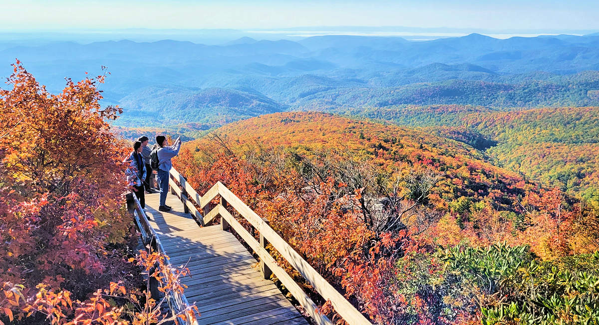
Rough Ridge: One of the most scenic hiking trails along the Blue Ridge Parkway takes you along the rocky slopes overlooking Grandfather Mountain. Part of the Tanawha Trail. (Photo at top!) Read more.
Tanawha Trail: This 13.5-mile hiking trail runs along the Blue Ridge Parkway and on the slopes of Grandfather Mountain. Easy to hike sections of this. Read more.
Appalachian Trail (Little & Big Hump): Take a 5-mile or 9-mile roundtrip hike to two bald summits with spectacular views on the AT. Read more.
Roan Highlands: This spectacular hike on the Appalachian Trail is 29 miles from Sugar Mtn, but worth the extra drive. Read more.
Elk River Falls: A short hike of about a half mile leads you to a 50-foot waterfall cascading over a cliff. Read more.
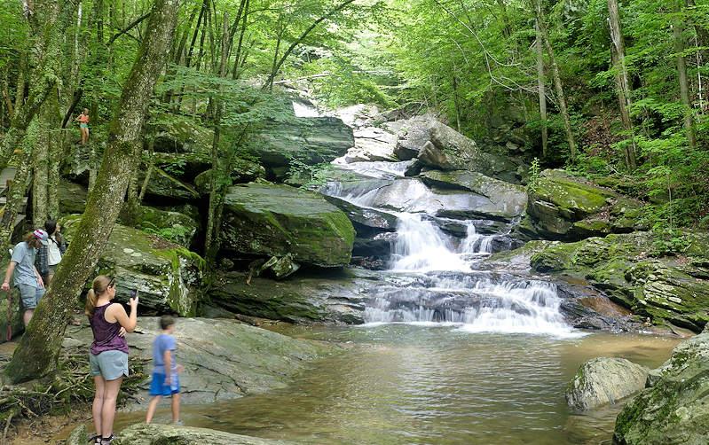
Also: Take a photo tour of 5 Waterfalls Near Sugar Mountain.
All of these hikes are also convenient to the surrounding towns and communities including Banner Elk, Linville Ridge, Grandfather Club, Diamond Creek, Elk River and Eagle’s Nest. See many more things to do during your visit!
NC Blue Ridge Waterfall & Hiking Safety Tips
Enjoy our great outdoors even more with these helpful tips for finding waterfalls and hiking our trails.
Tips for Chasing Waterfalls
- Most waterfalls require a hike – often in remote areas.
- Never climb on or around waterfalls. Deaths occur every year from slipping and falling.
- Do not jump off waterfalls or dive into pools since rocks, currents and logs can be hidden beneath the water surface.
- Do not get into the stream or river above a waterfall, since currents could take you over the falls. Most waterfalls are in remote areas, so a medical rescue could take hours.
- Cell phone service is very limited.
- Some waterfalls have a safe area for wading downstream from the waterfall, but rocks can be very slippery and sharp. Watch your step!
- Trails to waterfalls often have slippery rocks or mud along the trail. Wear hiking shoes with great grips. Watch for icy spots during the winter.
- Most of the waterfalls are not signed along the road. Often, locations marked on Google Maps are not accurate. Research ahead for exact driving directions.
- Bring an extra pair of shoes and socks for the car in case your feet get wet. An extra change of clothes is a good idea in case you are caught in a summer thunderstorm.
- Practice “Leave No Trace” by removing any trash and respecting all plants and wildlife. Read the 7 easy principles.
- Be aware of the time for sunset and get back to your car before night.
- During the winter, watch for icy patches along the trail and from mist of the waterfalls. Many times, a winter view is better since there are no leaves on the trees to hide parts of the falls.
Mountain Hiking Tips
- Tell someone where you are going and when you plan to return, especially if hiking alone.
- Do research ahead and print instructions on hikes, since cell phone reception in the mountains is limited, so many apps will not work.
- Go early in the day to avoid midday crowds and heat.
- Take extra clothes and rain gear, in case of a quick weather change. Higher elevation hikes can be 15-20 degrees cooler than the city. Wear layers and good hiking shoes.
- Stay on marked trails, and do not disturb any wildlife or plantlife.
- Practice “Leave No Trace” by removing any trash and respecting all plants and wildlife. Read the 7 easy principles.
- Bear sightings are rare. Usually they run away from humans.
- Take plenty of drinking water and snacks.
- Trail lengths can be misleading if the trail has a big elevation gain. A steep one mile hike is often more challenging than a 5 mile flat hike.
- Dogs are allowed on most hiking trails on a leash.